State Route 68
|
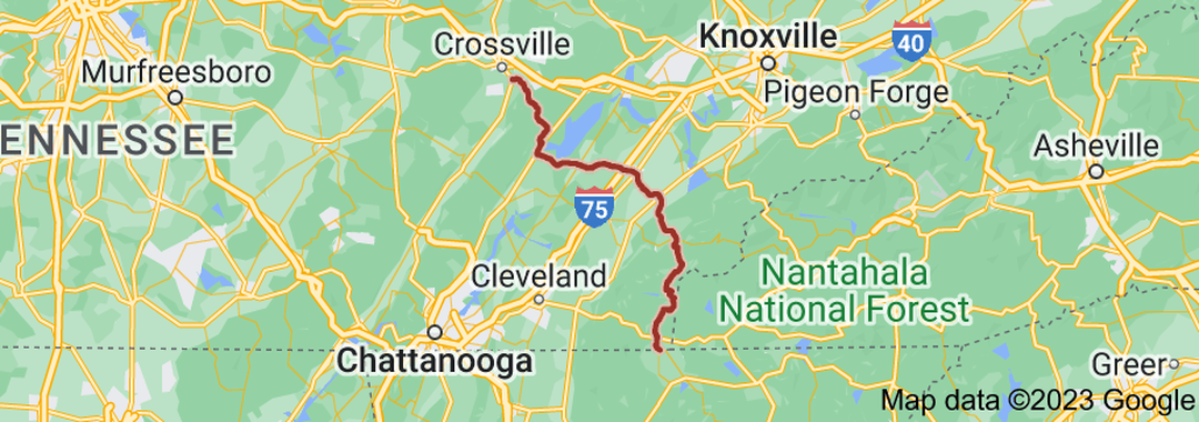
State Route 68 (SR 68) is a 106.89-mile-long (172.02 km) state highway in the eastern part of the U.S. state of Tennessee.
SR 68 begins in southeastern Tennessee, at an intersection with Georgia State Route 5 (SR 5) and SR 60 at the Tennessee–Georgia state line in Copperhill, Tennessee, and McCaysville, Georgia. It then goes north to Ducktown where it junctions with U.S. Route 64 (US 64) and US 74. The route continues north and enters the Cherokee National Forest and goes through a mostly rural area, then in Turtletown it turns east and junctions with SR 123. SR 68 then turns back north and continues through a sparsely populated area and crosses over the Hiwassee River. The route then becomes curvy and dangerous. It then enters Monroe County and goes through Coker Creek and then Tellico Plains and junctions with SR 165 (Cherohala Skyway). In Tellico Plains, SR 68 serves as the eastern terminus for SR 39; it then proceeds north to Madisonville where it meets US 411/SR 33. After this junction, the route then turns more northwesterly toward Sweetwater and passes The Lost Sea. In Sweetwater, it turns west and junctions with US 11 and Interstate 75 (I-75). |
|
Length of Route
106.89 mi. |
Begins:
SR 5/SR 60 at the Georgia state line in Copperhill |
Ends:
US 127/SR 29 near Crossville |
Counties Covered:
Polk, Monroe, McMinn, Meigs, Rhea, Cumberland
Polk, Monroe, McMinn, Meigs, Rhea, Cumberland
State Route 68 Images: